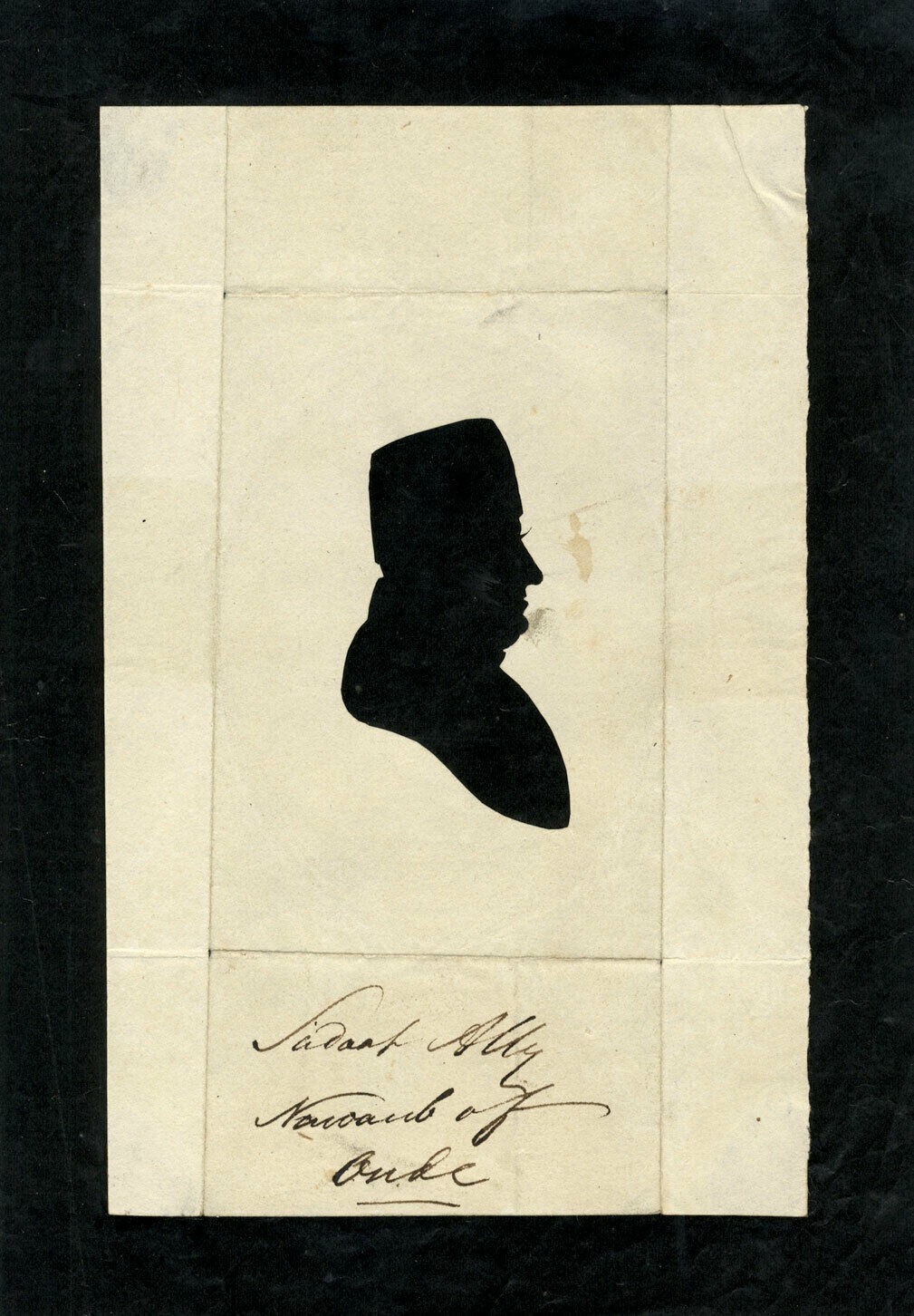
Saadat Ali Khan Nawab of Awadh Silhouette c1780 Sarah Harrington Circle Portrait

When you click on links to various merchants on this site and make a purchase, this can result in this site earning a commission. Affiliate programs and affiliations include, but are not limited to, the eBay Partner Network.

Saadat Ali Khan Nawab of Awadh Silhouette c1780 Sarah Harrington Circle Portrait:
$25000.00
This is a remarkable historical find. You have a hollow-cut silhouette from the late 18th century, attributed to the circle of Sarah Harrington, depicting Saadat Ali Khan II, the Nawab of Awadh.
This is an exceptional and rare hollow-cut silhouette dating to approximately the 1780s. It depicts Saadat Ali Khan II, who would later become the Nawab of Awadh (Oudh) in India. The work is attributed to the Circle of Sarah Harrington, a pioneering female silhouette artist of the 18th century known for her mechanical "physiognotrace" technique.
Transcription of TextFront (Handwritten Ink): "Saadat Ali Khan"
Back (Handwritten Ink): "Saadat Ali Khan / 1780s / Circle of Sarah Harrington"
Saadat Ali Khan II (r. 1798–1814): Saadat Ali Khan was the son of Shuja-ud-Daula. Before ascending the throne of Awadh, he spent significant time in exile and was known for his interactions with the British East India Company. This portrait likely captures him during his younger years in the 1780s. He was a great patron of the arts and architecture, responsible for much of the transformation of Lucknow into a "City of Palaces."
+1Sarah Harrington (fl. 1770–1800): Sarah Harrington was one of the most famous professional "silhouettists" of the Georgian era. She held a patent for a "new-invented instrument" that allowed her to create incredibly accurate profiles (hollow-cuts) in mere moments. Her work is highly sought after by collectors of early portraiture and feminist art history.
Item Details & ConditionType: Hollow-cut silhouette (the profile is cut out of the paper, showing the dark backing through the void).
Period: George III / Late 18th Century (c. 1780).
Subject: Indo-Persian Royalty / Nawab of Awadh.
Style: Neo-Classical Profile.
Condition: Excellent for its age. Minor age-toning to the paper which adds to its authentic antique character. Framed in a period-appropriate style.
Primary: Antique Silhouette, Hollow Cut, 18th Century Art, Anglo-Indian History, Nawab of Oudh, Lucknow, Sarah Harrington, Georgian Portrait.
Secondary: Profile Portrait, Physiognotrace, East India Company Era, Indian Royalty, Rare Ephemera.
This is a rare and historically significant hollow-cut silhouette dating from the 1780s. It features an exquisite profile portrait of Saadat Ali Khan II, the Nawab of Oudh (Awadh), and is attributed to the Circle of Mrs. Sarah Harrington. Harrington was a celebrated 18th-century professional silhouettist known for her pioneering "physiognotrace" technique, which allowed for remarkably accurate profile captures.
Full Transcription of TextFront (Handwritten): "Saadat Ali Khan"
Back (Handwritten): "Saadat Ali Khan / 1780s / Circle of Sarah Harrington"
Saadat Ali Khan II (r. 1798–1814): Saadat Ali Khan II was a prominent ruler of the Kingdom of Awadh (Oudh) in Northern India. This portrait likely captures him in the 1780s, a period marked by his interactions with the British East India Company and his eventual ceding of half his kingdom to the British in 1801. He is remembered as a great patron of arts and architecture, responsible for building many of the iconic "palaces" in Lucknow.
Sarah Harrington (fl. 1770s–1800): Mrs. Sarah Harrington was a leading figure in early portraiture. She held a patent for a mechanical instrument used to create these detailed "hollow-cut" silhouettes, where the profile is cut out of paper to reveal a dark backing underneath. Her works, often identifying high-society sitters, are highly collectible examples of Georgian-era folk and professional art.
Yameen-ud Daula Saadat Ali Khan II Bahadur (bf. 1752 – c. 11 July 1814) was the sixth Nawab of Oudh from 21 January 1798 to 11 July 1814, and the son of Shuja-ud-Daula. He was of Persian origin.[2][3]
LifeHe was the second son of Nawab Shuja-ud-daula. Saadat Ali Khan succeeded his half-nephew, Mirza Wazir `Ali Khan, to the throne of Oudh in 1798. Saadat Ali Khan was crowned on 21 January 1798 at Bibiyapur Palace in Lucknow, by Sir John Shore.[4]In 1801, the British concluded a treaty with him, by which half of his dominions were ceded to the East India Company, in return for perpetual British protection of Oudh, from all internal and external disturbances and threats (the British were to later renege on this promise). The districts ceded (then yielding a total revenue of 1 Crore & 35 Lakhs of Rupees) are as under:[1]• Etawa• Kora• Kurra• Rehur• Farruckabad• Khyreegurh• Mounal• Kunchunpore• Azimgarh• Benjun• Goruckpore• Botwul• Allahabad• Bareilly• Moradabad• Bijnore• Budown• hilibheet• Shahjehanpore• Nawabgunge• Rehlee• Mohowl (less Jaulluk Arwu)Following the cessation, he reduced the Oudh Army from 80,000 to 30,000 men.[1]He had three sons, Ghazi ad-Din Haydar, Shams-ud-daula, and Nasser-ud-daula. His son Ghazi ad-Din succeeded him, and later his grandson, Nasser ad-Din Haydar. After that, his son Nasser-ud-daula succeeded the throne, whilst his grandson, Iqbal-ud-daula, son of Shams-ud-daula, made claims to the throne in 1838.[5] It is important to note that Saadat Ali Khan preferred his son Shams-ud-daula and desired to proclaim his heir, but was prevented by British interference.[6]Most of the buildings between the Kaiserbagh and Dilkusha were constructed by him. He had a palace called Dilkusha Kothi designed and built by Sir Gore Ouseley in 1805.[7]
DeathNawab Saadat Ali Khan died in 1814 and he was buried with his wife Khursheed Zadi at Qaisar Bagh.[4]
Gallery Gates of the Palace at Lucknow by W. Daniell, 1801
Gates of the Palace at Lucknow by W. Daniell, 1801
Claude Martin's home that was bought by Saadat Ali Khan for 50K rupees
Claude Martin's home that was bought by Saadat Ali Khan for 50K rupees
Tomb of Nawab Saadat Ali Khan II, at Qaiser Bagh, Lucknow
Tomb of Nawab Saadat Ali Khan II, at Qaiser Bagh, Lucknow
The Nawab of Awadh or Nawab of Oudh /ˈaʊd/ was the title of the rulers of Kingdom of Awadh (anglicised as Oudh) in northern India during the 18th and 19th centuries. The Nawabs of Awadh belonged to an Iranian dynasty[1][2][3] of Sayyid origin[4][5] from Nishapur, Iran. In 1724, Nawab Sa'adat Khan established the Kingdom of Awadh with their capital in Faizabad and Lucknow.
History
See also: Oudh StateThe Nawabs of Awadh were semi-autonomous rulers within the fragmented polities of Mughal India after the death of Aurangzeb in 1707. They fought wars with the Peshwa, the Battle of Bhopal (1737) against the Maratha Confederacy (which was opposed to the Mughal Empire), and the Battle of Karnal (1739) as courtiers of the Moghul.[6]The Nawabs of Awadh, along with many other Nawabs, were regarded as members of the nobility of the Mughal Empire. They joined Ahmad Shah Durrani during the Third Battle of Panipat (1761) and restored Shah Alam II (r. 1760–1788 and 1788–1806) to the imperial throne. The Nawab of Awadh also fought the Battle of Buxar (1764) preserving the interests of the Mughal. Oudh State eventually declared itself independent from the rule of the Mughal in 1818.[7]
List of rulersAll of these rulers of the Royal House of Awadh used the title of Nawab from 1722 onward:
No. Portrait Titular Name Personal Name Birth Reign Death
1 Burhan ul Mulk Sa'adat Khan
برہان الملک سعادت خان Saadat Ali Khan I
سعادت علی خان 1680 Nishapur, Khurasan, Safavid dynasty, Persia 1722 – 19 March 1739 1739
2 Abul-Mansur Khan Safdar Jung
ابو المنصور خان صفدرجنگ Muhammad Muqim
محمد مقیم 1708 1739 – 5 October 1754 1754
3 Shuja-ud-Daula
شجاع الدولہ Jalal-ud-din Haider Abul-Mansur Khan
جلال الدین حیدر ابا المنصور خان 1732 1754 – 26 January 1775 1775
4 Asaf-ud-Daula
آصف الدولہ Muhammad Yahya Mirza Amani 1748 26 January 1775 – 20 April 1797 1798
5 Asif Jah Mirza
آصف جاہ میرزا Wazir Ali Khan
وزیر علی خان 1780 21 September 1797 – 21 January 1798 1817
6 Yamin-ud-Daula
یمین الدولہ Saadat Ali Khan II
سعادت علی خان دوم 1752 21 January 1798 – 11 July 1814 1814
7 Ghazi-ud-Din Haidar Shah
غازی الدین حیدر شاہ Ghazi-ud-Din Haidar Shah
غازی الدین حیدر شاہ 1769 11 July 1814 – 19 October 1827 1827
8 Abul- Mansur Qutub-ud-din Sulaiman jah
ابا المنصور قطب الدین سلیمان جاہ Nasir-ud-Din Haidar Shah
ناصر الدیں حیدر شاہ 1803 19 October 1827 – 7 July 1837 1837
9 Abul Fateh Moin-ud-din
ابا الفاتح معین الدین Muhammad Ali Shah
محمّد علی شاہ 1777 7 July 1837 – 7 May 1842 1842
10 Najm-ud-Daula Abul-Muzaffar Musleh-ud-din
نجم الدولہ ابا المظفر مصلح الدین Amjad Ali Shah
امجد علی شاہ 1801 7 May 1842 – 13 February 1847 1847
11 Abul-Mansur Mirza
ابا المنصور میرزا Wajid Ali Shah
واجد علی شاہ 1822 13 February 1847 – 11 February 1856 1 September 1887
12 Mohammadi Khanum
محمدی خانم Begum Hazrat Mahal
بیگم حضرت محل 1820 11 February 1856 – 5 July 1857
Wife of Wajid Ali Shah and mother of Birjis Qadra (in rebellion) 7 April 1879
13 Ramzan Ali
رمضان علی Birjis Qadr
بر جیس قدر 1845 5 July 1857 – 3 March 1858
(in rebellion) 14 August 1893The Oudh State (English: /ˈaʊd/, Hindi: [ˈəʋədʱ] ⓘ,[2] also Kingdom of Awadh, Kingdom of Oudh, Awadh Subah, Oudh Subah, or Awadh State) was a Mughal subah, then an independent kingdom, and lastly a British protectorate in the Awadh region of North India until its annexation by the British East India Company in 1856. The name Oudh, now obsolete, was once the anglicized name of the state, also written historically as Oudhe.As the Mughal Empire declined and decentralized, local governors in Oudh began asserting greater autonomy, and eventually Oudh matured into an independent polity governing the fertile lands of the Central and Lower Doab.The capital of Oudh was in Faizabad, but the company's Political Agents, officially known as "Residents", had their seat in Lucknow. At par existed a Maratha embassy, in the Oudh court, led by the Vakil of the Peshwa, until the Second Anglo-Maratha War. The Nawab of Oudh, one of the richest princes, paid for and erected a Residency in Lucknow as a part of a wider programme of civic improvements.[3]Oudh joined other Indian states in an upheaval against British rule in 1858 during one of the last series of actions in the Indian rebellion of 1857. In the course of this uprising, detachments of the Bombay Army of the East India Company overcame the disunited collection of Indian states in a single rapid campaign. Determined rebels continued to wage sporadic guerrilla clashes until the spring of 1859. This rebellion is also historically known as the Oudh campaign.[4]After the British annexation of Oudh by the Doctrine of Lapse, the North Western Provinces became the North Western Provinces and Oudh.[5]
History
See also: Oudh Bequest
Elaborately illustrated map of the Awadh Subah of the Mughal Empire, commissioned by Jean Baptiste Joseph Gentil, ca.1770Oudh Subah was one of the initial 12 subahs (later expanded to 15 subahs by the end of Akbar's reign) established by Akbar during his administrative reforms of 1572–1580. A Mughal Subah was divided into Sarkars, or districts. Sarkars were further divided into Parganas or Mahals. Saadat Ali Khan I was appointed Subahdar of Oudh Subah on 9 September 1722, succeeding Girdhar Bahadur. He immediately subdued the autonomous Shaikhzadas of Lucknow and Raja Mohan Singh of Tiloi, consolidating Oudh as a state. In 1728, Oudh further acquired Varanasi, Jaunpur and surrounding lands from the Mughal noble Rustam Ali Khan and established stable revenue collection in that province after quelling the chief of Azamgarh, Mahabat Khan.[6]: 44 In 1739 Saadat Khan mobilized Oudh to defend against Nader Shah's invasion of India, ultimately being captured in the Battle of Karnal. He attempted to negotiate with Nader Shah but died in Delhi.
EstablishmentIn 1740, his successor Safdar Jang moved the capital of the state from Ayodhya to Faizabad.[7] Safdar Jang gained recognition from Persia after paying tribute. He continued Saadat Khan's expansionist policy, promising military protection to Bengal in exchange for the forts at Rohtasgarh and Chunar, and annexing portions of Farrukhabad with Mughal military aid which was ruled by Muhammad Khan Bangash.As the Mughal Empire began to dissolve in the early 18th century, many subahs became effectively independent.[8] As regional officials asserted their autonomy in Bengal and the Deccan as well as with the rise of the Maratha Empire, the rulers of Oudh gradually affirmed their own sovereignty. Safdar Jang went as far as to control the ruler of Delhi, putting Ahmad Shah Bahadur on the Mughal throne with the cooperation of other Mughal nobility. In 1748 he gained the subah of Allahabad with Ahmad Shah's official support. This was arguably the zenith of Oudh's territorial span.[9]: 132 [10]: 193 The next nawab, Shuja-ud-Daula, extended Oudh's control of the Mughal emperor. He was appointed vazir to Shah Alam II in 1762 and offered him asylum after his failed campaigns against the British in the Bengal War.[10]
British contact and controlSince Oudh was located in a prosperous region, the British East India Company soon took notice of the affluence in which the Nawabs of Oudh lived. Primarily, the British sought to protect the frontiers of Bengal and their lucrative trade there; only later did direct expansion occur.
Shuja-ud-Daula
See also: Shuja-ud-DaulaBritish dominance was established at the Battle of Buxar of 1764, when the East India Company defeated the alliance between the nawab of Oudh Shuja-ud-Daula and the deposed nawab of Bengal Mir Kasim.[11]: 25 The battle was a turning point for the once rising star of Oudh. The immediate effect was the British occupation of the fort at Chunar and the cession of the provinces of Kora and Allahabad to Mughal ruler Shah Alam II under the Treaty of Benares (1765). Shaja-ud-Daula further had to pay 5 million rupees as an indemnity, which was paid off in one year.[12]: 158 [10]: 252 The long-term result would be direct British interference in the internal state matters of Oudh, useful as a buffer state against the Marathas. The treaty also granted British traders special privileges and exemptions from many customs duties, which led to tensions as British monopolies were established.Shuja-ud-Daula bought the Mughal provinces of Kora and Allahabad in the Treaty of Benares (1773) with the British (who held de facto control over the area) for 50 lakh rupees, increased the cost of Company mercenaries, and military aid in the First Rohilla War to expand Oudh as a buffer state against Maratha interests.[11]: 65 [12]: 75 Done by Warren Hastings, this move was unpopular among the rest of Company leadership, but Hastings continued a harsh policy on Oudh, justifying the military aid as a offer to strengthen Oudh's status as a buffer state against the Marathas. To shape the policy of Oudh and direct its internal affairs Hastings appointed the resident Nathaniel Middleton in Lucknow that year as well. At the conclusion of the First Rohilla War in 1774, Oudh gained the entirety of Rohilkhand and the Middle Doab region, only leaving the independent Rampur State as a Rohilla enclave.[citation needed]
Asaf-ud-Daula
See also: Asaf-ud-DaulaAsaf-ud-Daula acceded to the nawabship of Oudh with British aid in exchange for the Treaty of Benares (1775) which further increased the cost of mercenaries and ceded the sarkars of Benares, Ghazipur, Chunar, and Jaunpur. From this time onwards, Oudh consistently complied with the company's demands, which continued to demand more land and economic control over the state.[13]The Treaty of Chunar (1781) sought to reduce the number of British troops in Oudh's service to cut costs, but failed in this measure due to the instability of Asaf-ud-Daula's rule and thus his reliance on British aid essentially as a puppet regime.[14]
Later rulersSaadat Ali Khan II acceded to the throne of Oudh in 1798, owing his seat to British intervention including Governor-General of Bengal Sir John Shore's personal proclamation in Lucknow of his rule. A treaty signed on 21 February 1798 increased the subsidy paid to the British to 70 lakh rupees per year.[13]In light of the Napoleonic Wars and British demands for greater revenue from the company, in 1801, Saadat Ali Khan II ceded the entire Rohilkhand and Lower Doab as well as the sarkar of Gorakhpur under the pressure of Lord Wellesley to the British in lieu of the annual tribute.[15] The cession halved the size of the polity, reducing it to the original Mughal subah of Awadh (excepting Gorakhpur which was ceded) and surrounded it by directly administered British territory, rendering it useless as a buffer. The treaty also mandated a government to be put in place that primarily served the citizens of Oudh. It was on the basis of the failure to meet this demand that the British later justified the annexation of Oudh.Farrukhabad and Rampur was not annexed by the British yet; instead, they served as separate princely states for the moment.[13]The kingdom became a British protectorate in May 1816. Three years later, in 1819, the Ghazi-ud-Din Haidar Shah took the title of Badshah (king), signaling formal independence from the Mughal Empire under the advice of the Marquis of Hastings.Throughout the early 1800s until annexation, several areas were gradually ceded to the British.
British annexation
Mutineer's Cavalry at Alam Bagh, LucknowOn 7 February 1856, by order of Governor-General Lord Dalhousie, the Nawab of Oudh, Wajid Ali Shah, was deposed, and Oudh State was annexed to the territories of the British East India Company under the terms of the Doctrine of lapse on the grounds of alleged internal misrule.[16]
Indian Rebellion of 1857Between 5 July 1857 and 3 March 1858, during the Indian Rebellion of 1857, Begum Hazrat Mahal, the wife of Wajid Ali Shah proclaimed their son Birjis Qadr the Wali of Awadh and ruled as regent. At the time of the rebellion, the British lost control of the territory; they reestablished their rule over the next eighteen months, during which time there were massacres such as those that had occurred in the course of the Siege of Cawnpore.[17][18]After the rebellion, Oudh's territory was merged with the North Western Provinces, forming the larger province of North-Western Provinces and Oudh. In 1902, the latter was renamed the United Provinces of Agra and Oudh. In 1921, it became the United Provinces of British India. In 1937, it became the United Provinces and continued as a province in independent India until finally becoming the state of Uttar Pradesh in 1950.[16]
Government
The fully-fledged state of Awadh
Feudatory statesThe following were feudatory estates —taluqdaris[19] or parganas— of Oudh: Balrampur Estate[20]
Benares State until 1740[21]
Bhadri Estate[22]
Itaunja Estate[23]
Kohra Estate[24]
Nanpara Taluqdari[25]
Pratapgarh Estate[26]
Tulsipur StateSubdvisionsAt the time of its creation by Akbar, the Subah of Oudh consisted of 5 sarkars, further subdivided into 38 article: Nawabs of OudhThe first ruler of Oudh State belonged to the Shia Muslim Sayyid Family and descended of Musa al-Kadhim originated from Nishapur. But the dynasty also belonged from the paternal line to the Kara Koyunlu through Qara Yusuf. They were renowned for their secularism and broad outlook.[28]All rulers used the title of 'Nawab'.[29]
Title Reign Start Reign End Name
Subadar Nawab 26 January 1722 19 March 1739 Borhan al-Molk Mir Mohammad Amin Musawi Saʾadat ʾAli Khan I
19 March 1739 28 April 1748 Abu'l Mansur Mohammad Moqim Khan
Nawab Wazir al-Mamalik 28 April 1748 13 May 1753
Subadar Nawab 5 November 1753 5 October 1754
5 October 1754 15 February 1762 Jalal ad-Din Shojaʾ ad-Dowla Haydar
Nawab Wazir al-Mamalik 15 February 1762 26 January 1775
26 January 1775 21 September 1797 Asaf ad-Dowla Amani
21 September 1797 21 January 1798 Mirza Wazir ʾAli Khan
21 Jan 1798 11 Jul 1814 Yamin ad-Dowla Nazem al-Molk Saʾadat ʾAli Khan II Bahadur
11 July 1814 19 October 1818 Ghazi ad-Din Rafaʾat ad-Dowla Abul-Mozaffar Haydar Khan
King (Padshah-e Awadh, Shah-e Zaman) 19 October 1818 19 October 1827
19 October 1827 7 July 1837 Naser ad-Din Haydar Solayman Jah Shah
7 July 1837 17 May 1842 Moʾin ad-Din Abu'l-Fath Mohammad ʾAli Shah
17 May 1842 13 February 1847 Naser ad-Dowla Amjad ʾAli Thorayya Jah Shah
13 February 1847 7 February 1856 Naser ad-Din ʾAbd al-Mansur Mohammad Wajed ʾAli Shah
5 July 1857 3 March 1858 Berjis Qadr (in rebellion)
Residents
Name Start End
Nathaniel Middleton 1773 1774
John Bristow 1774 1776
Nathaniel Middleton 1776 1779 (second time)
C. Purling 1779 1780
John Bristow 1780 1781 (second time)
Nathaniel Middleton 1781 1782 (third time)
John Bristow 1782 1783 (third time)
William Palmer 1783 1784
Gabriel Harper 1784 1785
Edward Otto Ives 1785 1794
George Frederick Cherry 1794 1796
James Lumsden 1796 1799
William Scott 1799 1804
John Ulrich Collins 1804 1807
John Baillie 1807 1815
Richard Charles Strachey 1815 1817
John.R. Monckton 1818 1820
Felix Vincent Raper 1820 1823
Mordaunt Ricketts 1823 1827
Thomas Herbert Maddock 1829 1831
John Low 1831 1842
James Caulfield (interí) 1839 1841
William Nott 1841 1843
George Pollock 1843 1844
J. D. Shakespear 1844 1845
T. Reid Davidson 1845 1847
Archibald Richmond 1847 1849
Sir William Henry Sleeman 1849 1854
Sir James Outram 1854 1856
DemographicsIn the early eighteenth century, the population of Oudh was estimated to be 3 million. Oudh underwent a demographic shift in which Lucknow and Varanasi expanded to become metropolises of over 200,000 people over the course of the 18th century at the expense of Agra and Delhi. During this period the land on the banks of the Yamuna suffered frequent dry spells, while the Baiswara did not.[30]: 38 Although it was ruled by Muslims, a majority, roughly four fifths, of Oudh's population were Hindus.[9]: 155 [31]
CultureThe Nawabs of Oudh were descended from a Sayyid line from Nishapur in Persia. They were Shia Muslims, and promoted Shia as the state religion.[14] Ghazi-ud-Din Haidar Shah instituted the Oudh Bequest, a system of fixed payments by the British paid to the Shia holy cities of Najaf and Karbala. These payments, along with lifelong stipends to the wives and mother of Ghazi-ud-Din served as interest on the Third Oudh Loan taken in 1825.[32]The cities of Allahabad, Varanasi, and Ayodhya were important pilgrimage sites for followers of Hinduism and other Dharmic religions. The town of Bahraich was also revered by some Muslims.[33]
See also Awadh region
Wajid Ali Shah
Begum Hazrat Mahal
List of Indian monarchs[broken anchor]
Oudh and Rohilkhand Railway
Oudh and Tirhut Railway
Oudh Bequest
North India is a geographical region, loosely defined as a cultural region comprising the northern part of India (or historically, the Indian subcontinent) wherein Indo-Aryans (speaking Indo-Aryan languages) form the prominent majority population, while Tibeto-Burmans (speaking Tibeto-Burman languages) form the significant minority population. It extends from the Himalayan mountain range in the north to the Indo-Gangetic Plain, the Thar Desert, till Central Highlands. It occupies nearly two-quarters of the area and population of India and includes one of the three mega cities of India: Delhi. In a more specific and administrative sense, North India can also be used to denote the northern Indo-Gangetic Plain within this broader expanse, to the Thar Desert.[2]Several major rivers flow through the region including the Indus, the Ganges, the Yamuna and the Narmada rivers. North India includes the states of Himachal Pradesh, Uttarakhand, Punjab and Haryana, Rajasthan, Uttar Pradesh, and union territories of Chandigarh, Delhi, Jammu and Kashmir and Ladakh. Occasionally, states of Western, Central and Eastern India are referred as "North Indian" in a broader term.[1] [16][17][18]Majority in North India speak Indo-Aryan languages. The region was the historical centre of the ancient Vedic culture, the Mahajanapadas, the medieval Delhi Sultanate and the modern Mughal India and Indian Empire, among many others. It has a diverse culture, and includes the Hindu pilgrimage centres of Char Dham, Haridwar, Varanasi, Vindhyachal, Ayodhya, Mathura, Prayagraj, Vaishno Devi and Pushkar, the Buddhist pilgrimage centres of Sarnath and Kushinagar, the Sikh pilgrimage centre of Golden Temple, as well as world heritage sites such as the Nanda Devi Biosphere Reserve, Khajuraho Temples, Hill Forts of Rajasthan, Jantar Mantar (Jaipur), Qutb Minar, Red Fort, Agra Fort, Fatehpur Sikri and the Taj Mahal. North India's culture developed as a result of interaction between Hindu and Muslim religious traditions.[19]
Northern Region/Zone
States under Northern Zonal Council in orangeThe terms 'North Zone,' 'North Region,' or 'Northern Cultural Zone' are used by various ministries of the Government of India to refer to the northernmost administrative division of the country, whether one of four or six. These terms are distinct from 'North India,' which refers to a much larger geo-cultural region.
Government of India definitionsThe Northern Zonal Council is one of the advisory councils, created in 1956 by the States Reorganisation Act to foster interstate co-operation under the Ministry of Home Affairs, which included the states of Chandigarh, Delhi, Haryana, Himachal Pradesh, Jammu and Kashmir, Ladakh, Punjab and Rajasthan.[16][17]The Ministry of Culture established the North Culture Zone in Patiala, Punjab on 23 March 1985. It differs from the North Zonal Council in its inclusion of Uttarakhand and the omission of Delhi.[20]The Geological Survey of India (part of the Ministry of Mines) in its Northern Region, included Uttar Pradesh and Delhi, but excluded Rajasthan and Chandigarh, with a regional headquarters in Lucknow.[18]
Colloquial definitions of Northern Region/Zone
Indian press definitionThe Hindu newspaper puts Bihar, Delhi and Uttar Pradesh related articles on its North pages.[3] Articles in the Indian press have included the states of Bihar,[4] Gujarat,[7][6] Jharkhand,[10] Madhya Pradesh,[5] and West Bengal[8][9] in North as well.
Latitude-based definitionThe Tropic of Cancer, which divides the temperate zone from the tropical zone in the Northern Hemisphere, runs through India, and could theoretically be regarded as a geographical dividing line in the country.[21] Indian states that are entirely above the Tropic of Cancer are Himachal Pradesh, Punjab, Haryana, Delhi, Uttarakhand, Uttar Pradesh and Bihar and most of North East Indian states. However that definition would also include major parts of Rajasthan, Madhya Pradesh, Jharkhand and West Bengal and minor regions of Chhattisgarh and Gujarat.
Anecdotal usageIn Maharashtra, the term "North Indian" is sometimes used to describe migrants from Uttar Pradesh and Bihar, often using the term bhaiya (which literally means 'elder brother') along with it in a derogatory sense.[22][23] However within Uttar Pradesh (literally meaning "North Province" in Hindi) itself, "the cultural divide between the east and the west is considerable, with the purabiyas (Easterners) often being clubbed with Biharis in the perception of the westerners."[24][25] The Government of Bihar official site places the state in the Eastern part of India.[26] Uttar Pradesh and Bihar are often considered as being a part of north India, however, within most modern definitions of North India, Bihar is not article: India § History
Ancient eraBy 55,000 years ago, the first modern humans, or Homo sapiens, had arrived on the Indian subcontinent from Africa, where they had earlier evolved.[29][30][31] The earliest known modern human remains in South Asia date to about 30,000 years ago.[29] After 6500 BC, evidence for domestication of food crops and animals, construction of permanent structures, and storage of agricultural surplus appeared in Mehrgarh and other sites in Balochistan, Pakistan.[32] These gradually developed into the Indus Valley Civilisation,[33][32] the first urban culture in South Asia,[34] which flourished during 2500–1900 BC north-western Indian subcontinent.[35] Among its urban centres, Kalibangan (in Rajasthan) and Rakhigarhi (in Haryana) were prominent.[34] These cities participated in a complex system of urban planning, long-distance trade, and craft production, sustained through a variety of subsistence strategies.
Urban planning and fire altars at Kalibangan reflect Harappan-era religious and civic life in northwestern India.Between 2000 BC and 1500 BC, several waves of Indo-Aryan migrations from Central Asia occurred and these migrants settled in the Indo-Gangetic Plain. The Vedas, the oldest scriptures associated with Hinduism,[36] were composed during this period,[37] and historians have analysed these to posit a Vedic culture in the Punjab region and the upper Gangetic Plain.[38] During the period 2000–500 BCE, many regions of the subcontinent transitioned from the Chalcolithic cultures to the Iron Age ones.[38] The caste system, which created a hierarchy of priests (Brahmins), warriors Kshatriyas, and commoners and peasants (Vaishyas and Shudras), and but which excluded certain peoples whose occupations were considered impure, arose during this period.[39]In the late Vedic period, around the 6th century BCE, the small states and chiefdoms of the Ganges Plain and the north-western regions had consolidated into 16 major oligarchies and monarchies that were known as the mahajanapadas.[40][41] Among these, Kuru, Panchala, Kosala, and Kashi, all located in present-day Uttar Pradesh and Haryana, figured prominently. The emerging urbanisation gave rise to non-Vedic religious movements, two of which became independent religions. Jainism came into prominence during the life of its exemplar, Mahavira.[42] Buddhism, based on the teachings of Gautama Buddha, attracted followers from all social classes excepting the middle class; chronicling the life of the Buddha was central to the beginnings of recorded history in India.[43][44][45] In an age of increasing urban wealth, both religions held up renunciation as an ideal,[46] and both established long-lasting monastic traditions. Notably, cities like Sarnath, Shravasti, and Kushinagar, became closely associated with the life of the Buddha and the early Buddhist sangha.
The Ashoka Pillar at Prayagraj also contains inscriptions attributed to the Gupta emperor Samudragupta.Politically, by the 3rd century BCE, the Kingdom of Magadha had annexed or reduced other states and evolved into the Magadha Empire under the House of Maurya.[47] Although the Mauryan capital was located in Pataliputra, cities such as Kaushambi and Prayag in Uttar Pradesh gained prominence as administrative and religious centres. The Magadhan Mauryan emperors are known as much for their empire-building and determined management of public life as for Ashoka's renunciation of militarism and far-flung advocacy of the Buddhist dhamma.[48][49] Under Ashoka, the spread of Buddhism was institutionalised, and pillar inscriptions appeared across northern India, including sites in Uttar Pradesh and Rajasthan.By the 4th and 5th centuries, the House of Gupta of Magadha had created a complex system of administration and taxation in the greater Ganges Plain; this system became a model for later Indian kingdoms.[50][51] Under the Guptas, a renewed Hinduism based on devotion, rather than the management of ritual, began to assert itself.[52] This renewal was reflected in a flowering of sculpture and architecture, which found patrons among an urban elite.[51] Classical Sanskrit literature flowered as well, and Indian science, astronomy, medicine, and mathematics made significant advances.[51]Following the decline of the Guptas, the Indian early medieval age, from 600 to 1200 AD, is defined by regional kingdoms and cultural diversity.[53] When Harsha of Kannauj, who ruled much of the Indo-Gangetic Plain from 606 to 647 CE, attempted to expand southwards, he was defeated by the Chalukya ruler of the Deccan.[54] When his successor attempted to expand eastwards, he was defeated by the Pala king of Bengal.[54] In Rajasthan, a constellation of Rajput clans rose to power, forging new dynasties and asserting martial values through courtly traditions and fortified architecture.At the same time, the hill regions of Himachal Pradesh and Uttarakhand remained under smaller principalities, shaped by geographic isolation and local cultural traditions. In the plains, cities such as Ajmer, Kannauj, and Varanasi emerged as religious and commercial centres, supported by an expanding temple economy and patronage networks. During this time, pastoral peoples, whose land had been cleared to make way for the growing agricultural economy, were accommodated within caste society, as were new non-traditional ruling classes.[55] The caste system consequently began to show regional differences.[55]
Indo-Muslim eraAfter the 10th century, Muslim Central Asian nomadic clans, using swift-horse cavalry and raising vast armies united by ethnicity and religion, repeatedly overran South Asia's north-western plains. A general Qutub-ud-din Aibak declared his independence and established the Sultanate of Delhi in 1206.[56] The sultanate was to control much of North India and to make many forays into South India. Although at first disruptive for the Indian elites, the sultanate largely left its vast non-Muslim subject population to its own laws and customs.[57][58] By repeatedly repulsing Mongol raiders in the 13th century, the sultanate saved India from the devastation visited on West and Central Asia, setting the scene for centuries of migration of fleeing soldiers, learned men, mystics, traders, artists, and artisans from that region into the subcontinent, thereby creating a syncretic Indo-Islamic culture in the north.[59][60]
The three Battles of Panipat fought in 1526, 1556, and 1761 were pivotal in shaping the political landscape of North India.In the early 16th century, northern India, then under mainly Muslim rulers,[61] fell again to the superior mobility and firepower of a new generation of Central Asian warriors.[62] A Turco-Mongol emir, Zahir-ud-din Mohammad "Babur", after defeating the Delhi Sultanate, upgraded himself from Emir and proclaimed himself as the Padishah of Hindustan. His successors were called Mughals or Moguls by European historians owing to the dynasty's Mongol origins. They did not stamp out the local societies it came to rule. Instead, it balanced and pacified them through new administrative practices[63][64] and diverse and inclusive ruling elites,[65] leading to more systematic, centralised, and uniform rule.[66] Eschewing tribal bonds and Islamic identity, especially under Akbar, the Mughals united their far-flung realms through loyalty, expressed through a Persianised culture, to an emperor who had near-divine status.[65]The State's economic policies, deriving most revenues from agriculture[67] and mandating that taxes be paid in the well-regulated silver currency,[68] caused peasants and artisans to enter larger markets.[66] The relative peace maintained by the empire during much of the 17th century was a factor in the economic expansion of the region,[66] resulting in greater patronage of painting, literary forms, textiles, and architecture.[69] During this time, religious movements such as Sikhism grew in strength in Punjab, particularly under later Gurus, who adopted a militarised posture in response to growing Mughal intolerance.
Modern eraBy the early 18th century, Mughal authority had weakened. In its place, regional powers in northern and western India, such as the Marathas, the Rajputs, and the Sikhs asserted political control.[70] This fragmentation, coupled with growing European trading influence,[71][72] created conditions that favoured British expansion. The East India Company, leveraging military superiority and access to local revenue systems, took control of much of North India by the early 19th century.[73][71][74][75] The annexation of Delhi (1803) and Oudh (1856) consolidated British political authority across the region.[76] By this time, with its economic power severely curtailed by the British Parliament and having effectively been made an arm of British administration, the East India Company began more consciously to enter non-economic arenas, including education, social reform, and culture.[77]
A 1912 map of Northern India, showing the major centres of the Indian Rebellion of 1857The appointment in 1848 of Lord Dalhousie as Governor General of India set the stage for changes essential to a modern state. These included the consolidation and demarcation of sovereignty, the surveillance of the population, and the education of citizens. Technological changes—among them, railways, canals, and the telegraph—were introduced not long after their introduction in Europe.[78][79][80][81] However, disaffection with the company also grew during this time and set off the Indian Rebellion of 1857. Fed by diverse resentments and perceptions, including invasive British-style social reforms, harsh land taxes, and summary treatment of some rich landowners and princes, the rebellion rocked many regions of northern and central India and shook the foundations of Company rule.[82][83] This widespread revolt saw intense fighting and significant uprisings in key northern cities like Delhi, Kanpur, Lucknow, Jhansi, and Meerut, which became focal points of resistance against British control.Although the rebellion was suppressed by 1858, it led to the dissolution of the East India Company and the direct administration of British territories in India by the British Crown. Proclaiming a unitary state and a gradual but limited British-style parliamentary system, the new rulers also protected princes and landed gentry as a feudal safeguard against future unrest.[84][85] In 1861, a supreme legislature for India was established — the Imperial Legislative Council of India. Further reforms also created a unified bank — the Imperial Bank of India, a police force — the Indian Imperial Police and a unified army — the Imperial Indian Army. In 1876, the Crown-ruled India and the numerous Indian states under the Crown's suzerainty formed a loose political union called the Indian Empire, and Queen Victoria was crowned the Empress of India in 1877. In the decades following, public life gradually emerged all over India, leading eventually to the founding of the Indian National Congress in 1885.[86][87][88][89]The rush of technology and the commercialisation of agriculture in the second half of the 19th century was marked by economic setbacks, and many small farmers became dependent on the whims of far-away markets.[90] There was an increase in the number of large-scale famines,[91] and, despite the risks of infrastructure development borne by Indian taxpayers, little industrial employment was generated for Indians.[92] There were also salutary effects: commercial cropping, especially in the newly canalled Punjab, led to increased food production for internal consumption.[93] The railway network provided critical famine relief,[94] notably reduced the cost of moving goods,[94] and helped nascent Indian-owned industry.[93] The imperial capital was shifted from Calcutta to Delhi in 1911.
The India Gate stands as a memorial to 74,187 soldiers of the British Indian Army who died between 1914 and 1921 in the First World War.After World War I, in which approximately one million Indians served in the Indian Army,[95] a new period began. It was marked by the enactment of the Montagu–Chelmsford Reforms as the Government of India Act 1919 but also repressive legislation, by more strident Indian calls for self-rule, and by the beginnings of a nonviolent movement of non-co-operation, of which Mahatma Gandhi would become the leader and enduring symbol.[96] During the 1930s, slow legislative reform was enacted; the Indian National Congress won victories in the resulting elections.[97] The next decade was beset with crises: Indian participation in World War II, the Congress's final push for non-co-operation, and an upsurge of Muslim nationalism. All were capped by the advent of independence in 1947, but tempered by the partition of India into two states: India and Pakistan.[98]
Contemporary eraThe partition of India caused significant upheaval, especially in Punjab and Delhi, with widespread violence and population displacement.[99] Jammu and Kashmir, which acceded to India amid conflict, became a central point of territorial disputes involving India, Pakistan, and China.[100] In the decades after independence, North India underwent major administrative changes. The princely states of the Rajputana Agency were merged to form Rajasthan in 1949.[101] In 1966, Punjab was reorganised along linguistic lines, creating Haryana, Himachal Pradesh, and the present-day Punjab.[102] Punjab also experienced a separatist insurgency in the 1980s.[103] The Union Territory of Delhi was renamed the National Capital Territory of Delhi in 1991, gaining a legislative assembly with limited powers.[104] The Uttarakhand movement, which gained traction in 1994, culminated with Uttarakhand being carved out of Uttar Pradesh as a separate hill state in 2000.[105]In 2019, the revocation of Article 370 of the Constitution of India changed Jammu and Kashmir's status, dividing it into two union territories Jammu and Kashmir and on the sand dunes at Thar Desert located in North Indian state of RajasthanTowards its north are the Himalayas which define the boundary between the Indian subcontinent and the Tibetan Plateau. To its west is the Thar Desert, shared between North India and Pakistan and the Aravalli Range, beyond which lies the state of Gujarat. The Vindhya mountains are, in some interpretations, taken to be the southern boundary of North India.The predominant geographical features of North India are: the Indo-Gangetic plain, which spans the states and union territories of Chandigarh, Delhi, Punjab, Haryana, Uttar Pradesh, Bihar, and West Bengal.
the Himalayas and sub-Himalayan belt, which lie in the states of Uttarakhand, Himachal Pradesh, Jammu and Kashmir and West Bengal;
the Thar Desert, which lies mainly in the state of Rajasthan.The states of Himachal Pradesh, Uttarakhand, and Jammu and Kashmir also have a large forest coverage.[109]
General climate
India's Köppen climate classification map[110] is based on native vegetation, temperature, precipitation and their seasonality. Major categories:
(Am) Tropical monsoon
(Aw) Tropical savanna, wet & dry
(BWh) Hot desert
(BWk) Cold desert
(BSh) Hot semi arid
(Cwa) Monsoon-influenced humid subtropical
(Cwb) Subtropical highlandNorth India lies mainly in the north temperate zone of the Earth.[111] Though cool or cold winters, hot summers, and moderate monsoons are the general patterns, North India is one of the most climatically diverse regions on Earth. During summer, temperatures often rise above 35 °C across much of the Indo-Gangetic plain, reaching as high as 50 °C in the Thar Desert, Rajasthan, and up to 49 °C in Delhi. During winter, the lowest temperatures on the plains dip below 5 °C and drop below freezing in some states. Heavy to moderate snowfall occurs in Himachal Pradesh, Ladakh, Jammu & Kashmir, and Uttarakhand. Much of North India is also notorious for heavy fog during the winters.Extreme temperatures among inhabited regions have ranged from −45 °C (−49 °F) in Dras, Ladakh[112] to 50.6 °C (123 °F) in Alwar, Rajasthan. Dras is claimed to be the second-coldest inhabited place on the planet (after Siberia), with a recorded low of −60 °C.[113][114][115]
New Delhi
Climate chart (explanation)
J
F
M
A
M
J
J
A
S
O
N
20
23
10
15
29
15
21
36
21
25
39
25
70
39
27
237
35
27
235
34
26
113
34
25
17
33
19
9
28
13
9
23
9
█ Average max. and min. temperatures in °C
█ Precipitation totals in mm
Source: NOAA
Imperial conversion
Amritsar
Climate chart (explanation)
J
F
M
A
M
J
J
A
S
O
N
33
22
6
48
27
11
29
34
16
25
39
21
62
39
25
231
35
25
187
34
25
96
35
22
18
32
15
6
27
9
Average max. and min. temperatures in °C
█ Precipitation totals in mm
Source: NOAA
Imperial conversion
PrecipitationThe region receives heavy rain in plains and light snow on Himalayas precipitation through two primary weather patterns: the Southwest Monsoon and the Western Disturbances. The Monsoon carries moisture northwards from the Indian Ocean, occurs in late summer and is important to the Kharif or autumn harvest.[116][117] Western Disturbances, on the other hand, are an extratropical weather phenomenon that carry moisture eastwards from the Mediterranean Sea, the Caspian Sea and the Atlantic Ocean.[118][119][120][121] They primarily occur during the winter season and are critically important for the Rabi or spring harvest, which includes the main staple over much of North India, wheat.[119] The states of Jammu and Kashmir, Himachal Pradesh and Uttarakhand receive very heavy snowfall in winter months, however glacial and alpine areas receive snowfall throughout the year in these states.
Traditional seasonsNorthern Indian tradition recognises six distinct seasons in the region: summer (grishma or garmi (jyesth- ashadh), May–June), rainy (varsha (shravan-bhadra), July–August), post-monsoon (sharad (ashivan-kartik), September–October, sometimes thought of as 'early autumn'), autumn (hemant (margh-paush), November–December, also called patjhar, lit. leaf-fall), winter (shishir or sardi (magh-phagun),January–February) and spring (vasant (chaitra-baishakh), March–April). The literature, poetry and folklore of the region uses references to these six seasons quite extensively and has done so since ancient times when Sanskrit was prevalent.[122][123][124] In the mountainous areas, sometimes the winter is further divided into "big winter" (e.g. Kashmiri chillai kalaan) and "little winter" (chillai khurd).[125]
DemographicsThe people of North India mostly belong to the Indo-Aryan ethno-linguistic branch,[citation needed] and include various social groups such as Brahmins, Rajputs, Gadarias, Kayasthas, Banias, Jats, Rors, Gurjars, Kolis, Yadavs, Khatris and Kambojs.[126][127][128] Minority ethno-linguistic groups including Dravidians, Tibeto-Burmans and Austroasiatics exist throughout the region.
Population of states and union territories of North India
(2011 Census of India) State or Union Territory Population
[129][130] Growth
(2001–2012) 2025 Population Estimate[131] Rural pop. Urban pop. Density
(per sq km)
[a] Sex ratio
(per 1000 female)
Nos. % Nos. %
States
Haryana 25,351,462 19.9% 30,936,000 16,509,359 65.12% 8,842,103 34.88% 573 879
Himachal Pradesh 6,864,602 12.9% 7,542,000 6,176,050 89.97% 688,552 10.03% 123 972
Punjab 27,743,338 13.89% 31,122,000 17,344,192 62.52% 10,399,146 37.48% 551 895
Rajasthan 68,548,437 21.3% 82,770,000 51,500,352 75.13% 17,048,085 24.87% 201 928
Uttar Pradesh 199,812,341 20.2% 240,468,000 155,317,278 77.73% 44,495,063 22.27% 828 912
Uttarakhand 10,086,292 18.8% 11,874,000 7,036,954 69.77% 3,049,338 30.23% 189 963
Union Territories
Chandigarh 1,055,450 17.2% 1,255,000 28,991 2.75% 1,026,459 97.25% 9,252 818
Jammu and Kashmir 12,267,032 23.6% 13,798,000 9,064,220 73.89% 3,202,812 26.11% 297 890
Ladakh 274,000 17.8% 304,000 43,840 16% 230,160 84% 2.8 853
NCT of Delhi 16,787,941 21.2% 22,146,000 419,042 2.5% 16,368,899 97.5% 11,297 868
ReligionHinduism is the dominant religion in North India. Other religions practised by various ethnic communities include Islam, Sikhism, Jainism, Zoroastrianism, Judaism, Baháʼí, Christianity, and Buddhism. Hindus constitute more than 80 per cent of the North India's population. The national capital of India, New Delhi, is overwhelmingly Hindu-majority with Hindus constituting nearly 90% of the capital city's population. The states of Rajasthan, Haryana, Himachal Pradesh are overwhelmingly Hindu-majority. Uttarakhand and Uttar Pradesh are also Hindu majority states, but have a large Muslim minority (14% In Uttarakhand, 19% in Uttar Pradesh). The union territory of Jammu and Kashmir has a Muslim majority, while Ladakh has a Muslim plurality with minority Hindus and Buddhists. The state of Punjab has a Sikh majority of 60% and is the homeland of Sikh religion.
Languages
Further information: Languages of India
Distribution of Indo-Aryan languagesLinguistically, North India is dominated by Indo-Aryan languages. It is in this region, or its proximity, that Sanskrit and the various Prakrits are thought to have evolved.[citation needed] Hindi is spoken in Western Uttar Pradesh and Delhi and by a large number of people in many urban centres across North India. Many other languages of the Central Indo-Aryan languages such as Awadhi, Braj, Haryanvi, Chhattisgarhi, Bundeli and Bagheli are spoken in Haryana, Uttar Pradesh, Madhya Pradesh and Chhattisgarh. Marwari, Harauti, Malvi, Gujarati, Khandeshi, Marathi and Konkani are spoken in Rajasthan, extreme Eastern Madhya Pradesh, Gujarat, Maharashtra and Goa. Towards the far north, languages of Dardic (such as Kashmiri) and Pahari (such as Dogri, Kumaoni and Garhwali) groups are spoken in Jammu and Kashmir, Himachal and Uttarakhand. Punjabi is spoken in Punjab. Bengali is spoken in West Bengal. Languages of Bihari group, such as Maithili, Magahi and Bhojpuri are spoken in Bihar and Jharkhand.[citation needed]A number of aboriginal languages of Austroasiatic and Dravidian origin are spoken in some regions.[134] Several Sino-Tibetan languages are spoken in the Himalayan region like Kinnauri,[134] Ladakhi, Balti, and Lahuli–Spiti languages.
Culture
North Indian Hindu bride in LehengaThe composite culture of North India is known as Ganga-Jamuni tehzeeb, a result of the amicable interaction of Hindus and Muslims there.[19]
Dance
See also: List of Indian folk dancesDance of North India too has diverse folk and classical forms. Among the well-known folk dances are the bhangra of the Punjab, Ghoomar of Rajasthan, Nati of Himachal Pradesh and rouf and bhand pather of Kashmir. Main dance forms, many with narrative forms and mythological elements, have been accorded classical dance status by India's National Academy of Music, Dance, and Drama such as Kathak.[135]
Clothing
Further information: Punjabi clothing, Jammu dress, and PhiranEach state of North India has its own regional forms of clothing: Uttar Pradesh: Chikan Suit, Pathani Salwar, Kurta Paijama, Lehenga, Gharara, Sari.[citation needed]
Jammu: Kurta/Dogri suthan and kurta/churidar pajama and kurta.[citation needed]
Kashmir: Phiran and poots.[citation needed]
Himachal Pradesh: Shalwar kameez, Kurta, Churidar, Dhoti, Himachali cap and angarkha.[citation needed]
Punjab/Haryana: Salwar (Punjabi) Suit, Patiala salwar, Punjabi Tamba and Kurta, Sikh Dastar, Phulkari, Punjabi Ghagra.[citation needed]
Uttarakhand: Rangwali Phichora.[citation needed]
Rajasthan: Traditional: Ghagra, choli, and odhni for women. Rajasthani pagdi, angarkha/kurta, and dhoti/pyjamas for Men. Mojari are worn for footwear. The pagdi is worn on many occasions, and is part of the heritage of Rajasthan with its many colours and textile design (Leheriya, Bandhej, and Gota Patti). Semi-Formal/Formal: Women often wear the Poshak, historically worn by royalty, and men often wear the Safa/Pagdi, Bandhgala (Jodhpuri suit) along with traditional pants like churidars, dhotis, and Jodhpuri pants. Footwear includes mojari, similar to the shoes found in Sindh.[136]Flora and fauna
Further information: Wildlife of India
Chinkara in Madhya Pradesh, India
Goat at Great Himalayan national Park in Himachal PradeshNorth Indian vegetation is predominantly subtropical evergreen forest in Uttar Pradesh, subtropical deciduous forest in East Rajasthan, Haryana, Punjab and Delhi, hot desert in western Rajasthan, Montane ecosystem in Himachal Pradesh, Uttarakhand, J&K, and cold desert in Ladakh, and the Spiti Valley of Himachal Pradesh. Of the moist deciduous trees sal, teak, Mahogany, sheesham (Indian rosewood) and poplar are some which are important commercially.[137] The thorn woodland region mainly contains shrubs and trees like babul, khejri, ronjh, and khair along with dhok and palash in upland regions. The Western Himalayan region abounds in chir, pine, deodar (Himalayan cedar), blue pine, spruce, various firs, birch and junipers.[138][139][140][141] The birch, especially, has historical significance in Indian culture due to the extensive use of birch paper (Sanskrit: bhurja patra) as parchment for many ancient Indian texts.[142][143] The Eastern Himalayan region consists of oaks, laurels, maples, rhododendrons, alder, birch and dwarf willows. Reflecting the diverse climatic zones and terrain contained in the region, the floral variety is extensive and ranges from Alpine to Cloud forests, coniferous to evergreen, and thick subtropical moist forests to cool temperate woods.[138][144]There are around 500 varieties of mammals, 2000 species of birds, 30,000 types of insects and a wide variety of fish, amphibians and reptiles in the region. Animal species in North India include elephant, bengal tiger, indian leopard, snow leopard, sambar (Asiatic stag), chital (spotted deer), hangul (red deer), hog deer, chinkara (Indian gazelle), blackbuck, nilgai (blue bull antelope), porcupine, wild boar, Indian fox, Tibetan sand fox, rhesus monkey, langur, jungle cat, striped hyena, golden jackal, black bear, Himalayan brown bear, sloth bear, and the endangered caracal.Reptiles are represented by a large number of snake and lizard species, as well as the ghariyal and crocodiles.[145] Venomous snakes found in the region include king cobra and krait. Various scorpion, spider and insect species include the commercially useful honeybees, silkworms and lac insects. The strikingly coloured bir bahuti is also found in this region.[146]The region has a wide variety of birds, including peafowl, parrots, and thousands of immigrant birds, such as the Siberian crane. Other birds include pheasants, geese, ducks, mynahs, parakeets, pigeons, cranes (including the celebrated sarus crane), and hornbills. great pied hornbill, Pallas's fishing eagle, grey-headed fishing eagle, red-thighed falconet are found in the Himalayan areas. Other birds found here are tawny fish owl, scale-bellied woodpecker, red-breasted parakeet, Himalayan swiftlet, stork-billed kingfisher and Himalayan or white-tailed rubythroat.[147][148]
Wildlife parks and reservesImportant national parks and tiger reserves of North India include:
Sultan- The largest tiger of Pilibhit Tiger ReservePilibhit Tiger Reserve: It is the most narrowly-forested reserve among all the Tiger reserves of India with density of 11 tigers per 100 km2,[b] The reserve's 97.6% area is located in Pilibhit district and 2.4% in Shahjahanpur district in the Rohilkhand region of Uttar Pradesh.[149][150] The core area of the reserve contains 127 species of mammals,[151] 556 birds species,[152][153] 37 species of reptiles and 87 species of amphibians,[154] as well as 79 species of fishes,[155] As of August 2025, reserve officials confirmed that reserve's core area hosts more than 79 adult tigers.[c][156][157]
Jim Corbett National ParkCorbett National Park: It was established in 1936 as Hailey National Park[158] along the banks of the Ramganga River. It is India's first National Park, and was designated a Project Tiger Reserve in 1973. Situated in Nainital district of Uttarakhand, the park acts as a protected area for the critically endangered Bengal tiger of India. Cradled in the foothills of the Himalayas, it comprises a total area of 500 km2 out of which 350 km2 is core reserve. This park is known not only for its rich and varied wildlife but also for its scenic beauty.Nanda Devi National Park and Valley of Flowers National Park: Located in West Himalaya, in the state of Uttarakhand, these two national parks constitute a biosphere reserve that is in the UNESCO World Network of Biosphere Reserves since 2004. The Valley of Flowers is known for its meadows of endemic alpine flowers and the variety of flora, this richly diverse area is also home to rare and endangered animals.Dachigam National Park: Dachigam is a higher altitude national reserve in the state of Jammu and Kashmir that ranges from 5,500 to 14,000 feet above sea level. It is home to the hangul (a red deer species, also called the Kashmir stag).Great Himalayan National Park: This park is located in Himachal Pradesh and ranges in altitude from 5,000 to 17,500 feet. Wildlife resident here includes the snow leopard, the Himalayan brown bear and the musk deer.Desert National Park: Located in Rajasthan, this national reserve features extensive sand dunes and dry salt lakes. Wildlife unique to the region includes the desert fox and the great Indian bustard.Kanha National Park: The sal and bamboo forests, grassy meadows and ravines of Kanha were the setting for Rudyard Kipling's collection of stories, "The Jungle Book". The Kanha National Park in Madhya Pradesh came into being in 1955 and forms the core of the Kanha Tiger Reserve, created in 1974 under Project Tiger.Vikramshila Gangetic Dolphin Sanctuary: Located in the state of Bihar, it is the only protected zone for the endangered Ganges and Indus river dolphin.Bharatpur Bird Sanctuary: It is one of the finest bird parks in the world, it is a reserve that offers protection to faunal species as well. Nesting indigenous water birds as well as migratory water birds and waterside birds, this sanctuary is also inhabited by sambar, chital, nilgai and boar.Dudhwa National Park: It covers an area of 500 km2 along the Indo-Nepal border in Lakhimpur Kheri District of Uttar Pradesh, is best known for the barasingha or swamp deer. The grasslands and woodlands of this park, consist mainly of sal forests. The barasingha is found in the southwest and southeast regions of the park. Among the big cats, tigers abound at Dudhwa. There are also a few leopards. The other animals found in large numbers, are the Indian rhinoceros, elephant, jungle cats, leopard cats, fishing cats, jackals, civets, sloth bears, sambar, otters, crocodiles and chital.Ranthambhore National Park: It spans an area of 400 km2 with an estimated head count of thirty two tigers is perhaps India's finest example of Project Tiger, a conservation effort started by the government in an attempt to save the dwindling number of tigers in India. Situated near the small town of Sawai Madhopur it boasts of variety of plant and animal species of North India.Kalesar National Park: Kalesar is a sal forest in the Shivalik Hills of Eastern Haryana state. Primarily known for birds, it also contains a small number of tigers and panthers.Sultanpur National Park: Sultanpur is a Ramsar wetland in Gurgaon district of southern Haryana along the Sahibi River. It is primarily known for the numerous migratory birds that come during winter with over 130 species being recorded such as Amur falcons and Egyptian vultures with antelopes like the nilgai also being common.[159][160] Main vegetation is thorn forest which includes babul, neem, and khair.[161]Asola Bhatti Wildlife Sanctuary: Asola is a dry forest spanning South Delhi, Gurgaon, and Faridabad district in Delhi and Haryana. It is located in the foothills of the Aravalli Range. The main vegetation is thorn forest which includes babul, dhok, palash, khejri, and khair. The primary fauna of this forest includes the Indian leopard, golden jackal, jungle cat, and striped hyena.[162][163]
Places of interest
icon
This section needs additional citations for verification. Please help improve this article by adding citations to reliable sources in this section. Unsourced material may be challenged and removed. (January 2025) (Learn how and when to remove this message)
Akshardham Temple, Delhi
NatureThe Indian Himalayas, the Thar desert and the Indo-Gangetic plain dominate the natural scenery of North India. The region encompasses several of the most highly regarded hill destinations of India such as Srinagar, Shimla, Manali, Nainital, Mussoorie, Kausani and Mount Abu. Several spots in the states of Uttarakhand and Himachal Pradesh provide panoramic views of the snow-clad Himalayan range. The Himalayan region also provides ample opportunity for adventure sports such as mountaineering, trekking, river rafting and skiing. Camel or jeep safaris of the Thar desert are also popular in the state of Rajasthan. North India includes several national parks and reserve area such as the Pilibhit Tiger Reserve, Nanda Devi Biosphere Reserve, Jim Corbett National Park, Keoladeo National Park Ranthambore National Park, Sundarbans National Park and the Kutch Desert Wildlife Sanctuary.
PilgrimageNorth India encompasses several of the holiest pilgrimage centres of Hinduism (Varanasi, Haridwar, Allahabad, Char Dham, Vaishno Devi, Rishikesh, Ayodhya, Mathura/Vrindavan, Pushkar, Prayag and two of the twelve Jyotirlinga sites), the most sacred destinations of Buddhism (Bodh Gaya, Sarnath and Kushinagar), the most regarded pilgrimage centres of Sikhism (Amritsar and Hemkund) and some of the highly regarded destinations in Sufi Islam (Ajmer and Delhi). The largest Hindu temple, Akshardham Temple, the largest Buddhist temple in India, Mahabodhi, the largest mosque in India, Jama Masjid, and the largest Sikh shrine, Golden Temple, are all in this region.[164][165]
Historical
The Taj Mahal at Agra
Amer Fort in RajasthanNorth India includes some highly regarded historical, architectural and archaeological treasures of India. The Taj Mahal, an immense mausoleum of white marble in Agra, is one of the universally admired buildings of world heritage.[166] Besides Agra, Fatehpur Sikri and Delhi also carry some great exhibits from the Mughal architecture. In Punjab, Patiala is known for being the city of royalty while Amritsar is a city known for its Sikh architecture and the Golden Temple. Lucknow has the famous Awadhi Nawab culture while Kanpur reflects Anglo-Indian architecture with monuments like All Souls Cathedral, King Edward Memorial, Police Quarters, Cawnpore Woollen Mills, Cutchery Cemetery etc. Khajuraho temples constitute another famous world heritage site. The state of Rajasthan is known for exquisite palaces and forts of the Rajput clans. Historical sites and architecture from the ancient and medieval Hindu and Buddhist periods of Indian history, such as Jageshwar, Deogarh and Sanchi, as well as sites from the Bronze Age Indus Valley civilisation, such as Manda and Alamgirpur, can be found scattered throughout northern India. Varanasi, on the banks of the River Ganga, is considered one of the oldest continuously inhabited cities in the world and the second oldest in India after Nalanda. Bhimbetka is an archaeological site of the Paleolithic era, exhibiting the earliest traces of human life on the Indian subcontinent.
Economy
Further information: Economy of IndiaThe economy of North India varies from agrarian in the northern plains to very industrialised in the National Capital Region. Northwest Indian plains have prospered as a consequence of the Green Revolution in Punjab, Haryana and western Uttar Pradesh, and have experienced both economic and social development.[167][168][169] The Eastern areas of East Uttar Pradesh, however, have lagged[170][171] and the resulting disparity has contributed to a demand for separate statehood in West Uttar Pradesh (the Harit Pradesh movement).[172][173]The major industrial regions in North India are the Gurugram-Delhi-Meerut Belt (NCR). North Indian state with highest GDP per capita in the Indian Union was Haryana in 2021. Other North Indian states which follow are Uttarakhand and Himachal Pradesh.[174] Delhi has the highest per-capita State Domestic Product (SDP) of any Indian union territory.[175] The National Capital Region of Delhi has emerged as an economic power house with rapid industrial growth.According to a 2009–10 report, a large number of unskilled and skilled workers have moved to southern India and other nations because of the unavailability of jobs locally.[176] The technology boom that occurred in the past three decades in southern India has helped many Indians from the northern region to find jobs and live prosperous lives in southern cities. An analysis by Multidimensional Poverty Index creators reveals that acute poverty prevails in eight Indian states including the northern states of Rajasthan and Uttar Pradesh.[177]
Cuisine
Popular dishesThe best-known[178] North-Indian food items are: Tandoori chicken
Reshmi kabab
Kadai paneer
Chole bhature
Aloo paratha
Butter chickenSee also Northeast India
Saadat Ali Khan Nawab of Awadh Silhouette c1780 Sarah Harrington Circle Portrait:
$25000.00
Related Items:
India Princely State Rajput Royalty Document Sultan Muhammad Saadat Ali Khan IN
$84.96

INDIA, LUCKNOW, TOMB OF SAADAT-ALI & MORSHIDZADI, c1910 ppc., unused..
$3.50